FALL 2023 DISTRICT WELL MEASUREMENTS
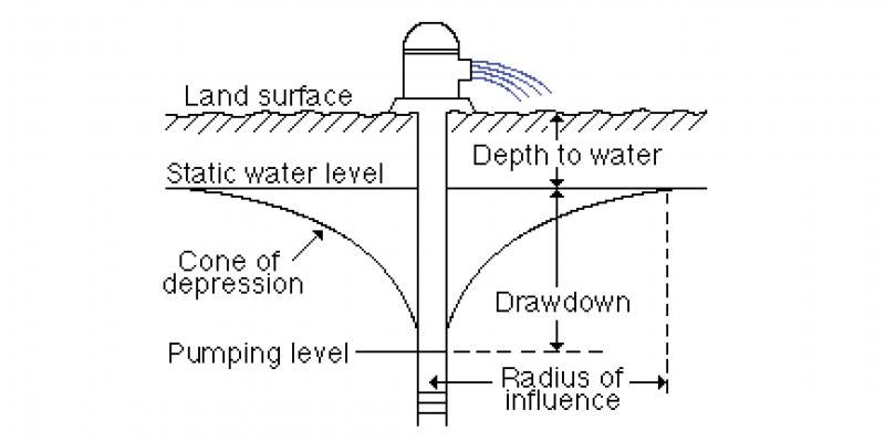
The static water level of 34 irrigation wells from selected locations throughout the Lewis and Clark Natural Resources District (LCNRD) is measured in the fall and spring each year. The summer of 2023 was the second season of higher than usual irrigation demands and lower than usual rainfall amounts. Many of the wells measured in local aquifers showed average water levels higher than the fall of 2022 with 21 of 34 wells indicating moderately higher water levels. Spring water levels are the primary gage for evaluating aquifer response because water levels have recovered from the pumping season the prior year.
LCNRD monitors water levels from four main aquifer types: undifferentiated sand and gravel, Missouri River Alluvium, Niobrara Formation or “chalk,” and Dakota Sandstone Formation aquifers. The average water level of wells developed in the undifferentiated sand and gravel aquifers, which encompass most of the well development across the district, reflected a slight static water level increase since last fall.
Wells along the Missouri River are typically constructed in the Missouri River Alluvium, and water levels in this aquifer correspond closely with the river. Levels in these wells increased on average 0.72 feet from the fall of 2022, and the average depth to water from the land surface is 20.38 feet. Higher water levels in this aquifer are likely related to higher river levels.
Comparison of water levels developed in Niobrara Formation wells were up on average 4.75 feet from last fall. The Niobrara aquifer is a confined aquifer system, and static water levels drop much more quickly under pumping pressure and rebound more quickly with abundant rainfall. The average depth of groundwater in the Niobrara aquifer is 28.41 feet. These wells are located primarily in northern Cedar County.
In 2013, LCNRD began measuring the water level in four Dakota Sandstone Formation wells. The average water level in these deeply buried sandstone wells was 8.21 feet higher this fall than last year's fall. Recharge in this system is much slower than those more commonly utilized in the District.
The purpose of well monitoring is to maintain a record of water levels and their fluctuations throughout the area. Persistent drought conditions could impact water levels in local aquifers. If necessary, the District would initiate irrigation control activities to protect groundwater levels through its authorities for groundwater management. Triggers for controls are based on spring water level readings.
The wells monitored for static water levels are located randomly across LCNRD from north of Ponca to Creighton. Areas of heavy irrigation are typically monitored more than other regions. Lower-than-average rainfall and average irrigation in 2023 have shown some decline in some sand and gravel aquifer groundwater levels. LCNRD anticipates water levels to recover slightly over the winter. If weather patterns continue and irrigation demand is lower, we expect levels to be steady in the spring and fall of 2024