Water Quality
The Bazile Groundwater Management Area (BGMA)
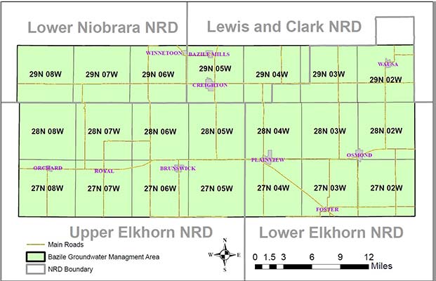
The Bazile Groundwater Management Area (BGMA) is comprised of four NRDs including the Lewis & Clark NRD, Lower Elkhorn NRD, Lower Niobrara NRD, and the Upper Elkhorn NRD. Within these four NRDs, the BGMA includes parts of three counties: Antelope, Knox and Pierce and the towns of Brunswick, Creighton, Orchard, Osmond, Plainview, Royal, Wausa, and Winnetoon. The BGMA was started by local producers and the NRDs to address rising nitrate levels in area communities and domestic wells. Currently, Creighton, Orchard, and Osmond are under administrative orders for high nitrate concentrations in public drinking water.
To address these issues, the NRDs along with local stakeholders from the BGMA, the Nebraska Department of Environment and Energy (NDEE), Natural Resources Conservation Service (NRCS), the Nebraska Environmental Trust (NET) and additional agencies have worked together to create a master plan for the BGMA.
The Bazile Creek watershed has been listed as an impaired watershed due to high levels of nitrate in the groundwater and has qualified for special National Water Quality Initiative (NWQI) funding through NRCS. Through this NRCS program, producers can obtain funding for numerous BMPs such as cover crops, filter strips, and irrigation system updates. Additional cost share programs may be available for each NRD or as part of the BGMA. Contact LCNRD for rules & regulations and cost share programs.


For more information on the BGMA go to the website bgma.nebraska.gov
or contact:
The Bazile Groundwater Management Area Project Coordinator
402-371-7313
BGMA Survey Results
This past spring the Bazile Groundwater Management Area (BGMA) Project conducted a short survey to better understand the perspectives and current practices of those living and/or working within the BGMA.
A summary of the results from the survey can be found below. A full draft report of the survey results is also available. The information gathered helps the BGMA Project Group better understand landowner and operator management in the BGMA.
![]()
BGMA in the Lewis & Clark NRD
The Lewis & Clark NRD in accordance with Nebraska Revised Statute 46-673.01 adopted the Lewis & Clark NRD Groundwater Management Plan (GWMP) which created triggers to implement stages of groundwater quality management. In 2004, the Lewis & Clark NRD Board of Directors established the Bazile Groundwater Management Area (BGMA). Designation occurred following the 2003 irrigation water quality sampling season. At that time more than 50% of irrigation wells monitored indicated nitrate levels greater than 10 parts per million (ppm), meeting the trigger for Phase III management.
The Phase III requirements provide guidelines to adopt best management practices (BMPs) to turn around the trend of increasing nitrate levels. The BGMA region includes the recharge area for the primary drinking water source that supplies the City of Creighton.
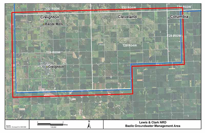
The Bazile Groundwater Management Area in the Lewis & Clark NRD includes:
- Columbia Twp – (T29N-R3W), Only Section 6, 7, 18, and 19
- Cleveland Twp – (T29N-R4W), All sections except Sec 25, 26, 27, 34, 35, 36
- All of Creighton Township – T29N-R5W
Overview of Rules and Regulations for the LCNRD portion of the BGMA
![]() 2023 Rules and Regulations of the GWMA
2023 Rules and Regulations of the GWMA
- Annually submit crop and fertilizer reports. Due March 1st of each year
- Nitrate Nitrogen fertilizer applicator must attend district education programs on BMP to minimize pollution (4-year Cert- no charge)
- Deep Soil testing required on acres to be planted to corn –
 2023 Deep Soil Brochure and Application Form. 50% cost share is available for deep soil testing - complete an application and return it to the LCNRD.
 - Irrigation wells tested every two years for nitrate nitrogen content by Lewis & Clark NRD
- No fall or winter application of nitrogen fertilizer is allowed
- Split application of spring applied fertilizer exceeding 100 lbs per acre is recommended.
Programs offered by Lewis & Clark NRD in the Bazile GMA
![]() 2023 Deep Soil Brochure and Application Form
2023 Deep Soil Brochure and Application Form
The Deep Soil Sampling Cost Share Program is designed to encourage farmers to better manage fertilizer application by knowing how much nitrogen exists in the full crop root zone.
The purpose of the Chemigation cost-share program is to encourage the split application of nitrogen fertilizer. The program is for first-time chemigators. LCNRD will pay $4.00 per irrigated acre for one pivot only. Payment will be made in the fall.
![]() Siphoning Nitrates with Irrigated Pasture or Hay
Siphoning Nitrates with Irrigated Pasture or Hay
Siphoning Nitrates with Irrigated Pasture or Hay (SNIP) is designed to encourage irrigated alfalfa or pasture management in previous-row crop areas to reduce nitrate-nitrogen concentrations in the soil and water.
Monitoring Well Network
The long-term goal of the observation well network is to define the groundwater flow system below the NRD. In order to accomplish this goal, test holes have been drilled, sampled and logged by University of Nebraska Lincoln (UNL) Conservation and Survey Division (CSD) geologists. The wells are designed using this information to monitor discrete intervals of the aquifer system. Beneath some of the proposed drilling sites there are multiple aquifers; therefore, there may be up to 3 wells at each site, monitoring water from different depths.
Once the monitoring wells are installed LCNRD staff can measure the depth to groundwater and collect groundwater samples for laboratory analysis of nitrate, chloride, sulfate and other groundwater components. Samples are taken monthly for the first year to assess the seasonal variations in water quality. If there is only a small amount of variation in concentrations the wells will be sampled on an annual or semiannual basis in order to assess long-term water quality trends.
The monitoring well network helps LCNRD improve identification of the geologic characteristics and groundwater resources within the LCNRD. Knowledge of the aquifers which provide the majority of our drinking water and irrigation water will be significantly improved, making it possible for the LCNRD staff and Board of Directors to monitor and manage our groundwater resource.
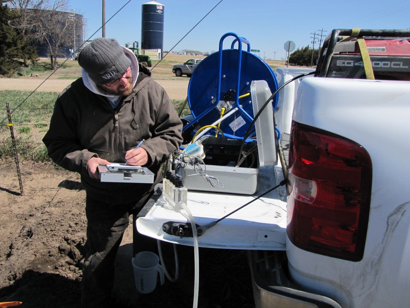
Irrigation Water Quality Monitoring
The LCNRD monitors water quality from 200+ irrigation wells across the district. In 1987 the Lewis and Clark NRD began monitoring the level of nitrate-nitrogen in groundwater across the LCNRD and continues to do so each year during the irrigation season. The majority of the monitored irrigation wells are near Creighton, where water quality sampling is required as part of the Rules and Regulations implemented with the Bazile Groundwater Management Area.
Samples are collected from pre-determined, active irrigation wells between July and September. Accurate representation of the nitrate concentration in the aquifer being sampled requires the irrigation well to run for 24 hours prior to sampling. Samples are kept cool and a preservative added to ensure sample integrity is maintained until it is shipped in an insulated shipping box to a certified laboratory for nitrate-nitrogen testing. The nitrate level is measured in parts per million (ppm) with 10ppm being the maximum contaminant level for drinking water according to EPA regulations.
Cooperators receive a copy of the testing results each year to track the nitrate concentration in the groundwater of their irrigation wells. Crops benefit from the nitrate-nitrogen in the groundwater and the amount of nitrogen fertilizer applied during the growing season can be reduced accordingly. Knowing the nitrate level may help a producer reduce the amount of nitrogen applied to the crop, which could save the producer money and improve water quality.
Water Quality Management Plan (WQMP)
The Lewis and Clark Natural Resources District (LCNRD) has developed a plan to improve the water quality and environmental integrity of local watersheds. The WQMP is based on the Environmental Protection Agency’s (EPA) nine key elements (9 Elements), requirements that are critical for achieving improvements in water quality.
Water Quality Concerns
LCNRD has found elevated levels of nutrients (nitrogen and phosphorus), sediment, and bacteria levels polluting local waterbodies. Levels exceed State standards which has resulted in 13 stream segments and 5 lakes being listed on Nebraska’s EPA 303(d) list of impaired waterbodies. A waterbody is considered impaired if it fails to meet one or more state water quality standards as monitored and reported by the Nebraska Department of Environmental Quality.
The primary cause of impairment in the WQMP area is nonpoint source pollution; pollutants generated from landscapes transported by surface water runoff. Pollutants leach into the groundwater, contaminating drinking water sources, raising human health concerns, and/or increasing treatment costs. Major pollutant sources in the LCNRD are a result of agricultural practices.
Our Plan
LCNRD and Nebraska Department of Environmental Energy (NDEE) partnered to develop the WQMP and have:
•Worked with a Technical Advisory Committee and Stakeholder Advisory Committee to identify priorities.
•Conducted a ‘big picture' assessment of impacts to water quality on a district-wide level.
•Conducted detailed assessment of pollutant sources and identified methods to address selected Priority and Special Priority Areas (see map below for locations).
•Developed a basin-wide EPA 9-Element Water Quality Management Plan (WQMP).
•Developed plan components eligible for EPA's 319 Grant Program funding
The WQMP Area was assessed to identify ‘hot spots (areas that contribute relatively more contamination to water bodies) based on a Water Quality Index (WQI) developed for the purpose of providing information to guide the selection of Priority Areas. The WQI was developed using EPA’s Recovery Potential Screening (RPS) tool. The WQI was designed to strictly reflect the potential for pollution, and the indicators were strategically selected and customized for the conditions in the WQMP Area.
Priority Area and Special Priority Areas Map
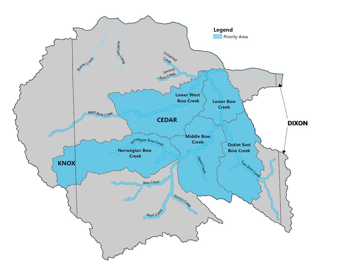
Priority Areas include sub-watersheds with the highest potential for pollution to Bow Creek, which is impaired for E. coli and includes all major stream corridors in the Bow Creek drainage area. Special Priority Areas (SPA) include Howe Creek SPA, a sub-watershed to the Bazile Creek formed in partnership with the Santee Sioux Nation and Bazile Creek Headwaters SPA, an overlap with the Bazile Groundwater Management Area Plan to support efforts to reduce groundwater nitrate levels.
A wide variety of management practices have been identified to reduce pollutant loading to water resources. These practices are to encourage producers to implement a systems approach of complementary practices that address specific, high-priority resource concerns in selected watersheds. Below are some priority conservation practices that can be implemented in farming operations.
|
Priority Conservation Practices |
|---|
|
No-Till Farming |
|
Cover Crops |
|
Land Use Change: Small Grains Crop Rotation |
|
Contour Farming |
|
Land Use Change: CRP |
|
Grassed Waterways |
|
Water and Sediment Control Basins (WASCOBs) |
|
Sediment Control Basin |
|
Constructed Wetlands |
|
Riparian Buffer/Filter Strips |
|
Grazing Management/Rotational Grazing |
|
Livestock Exclusion -Fencing & Alternate Water Source |
|
Manure Application and Nutrient Management |
|
Waste Water Management/Runoff Control |
|
Waste Storage Facilities |
|
Composting Facility |
|
Septic System Improvements |
|
Stream Bank Stabilization |
|
Grade Control Structure/In-Stream Weir |
View the complete ![]() Water Quality Management Plan (WQMP)
Water Quality Management Plan (WQMP)